
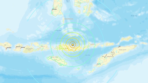
A powerful magnitude 7.7 earthquake struck off the coast of Indonesia on Wednesday, prompting regional authorities to issue an immediate tsunami warning. The U.S. Geological Survey detected the undersea tremor, which triggered automated seismic sensors across the Pacific region.
Emergency response teams mobilized quickly as authorities assessed structural integrity and coastal safety protocols. Initial evaluations focused on seismic data feeds and oceanographic buoy networks to measure wave displacement accurately.
Key Seismic Facts
- Magnitude measured at 7.7 by the U.S. Geological Survey.
- Epicenter located offshore near the Indonesian coastline.
- Tsunami warning issued immediately for vulnerable coastal zones.
- No immediate reports of casualties or major structural damage.
- Advanced monitoring networks deployed ocean buoys to track wave heights.
Geological Context of the Region
Indonesia sits firmly upon the Ring of Fire, a massive horseshoe-shaped basin in the Pacific Ocean. This region features frequent seismic activity and volcanic eruptions caused by colliding tectonic plates. The Indo-Australian, Pacific, and Eurasian plates grind against each other, accumulating immense stress until they fracture abruptly.
Subduction zones dominate this area, where one tectonic plate slides beneath another into the Earth’s mantle. When these locked zones rupture, they displace massive volumes of seawater. This displacement generates catastrophic seismic sea waves known as tsunamis.
Technological Advances in Tsunami Detection
Modern disaster mitigation relies on sophisticated sensor networks placed across the ocean floor. Deep-ocean assessment systems utilize bottom pressure recorders. These seafloor devices measure changes in water column pressure when a seismic wave passes.
Data transmits via acoustic modems to surface buoys, which relay critical telemetry to satellite networks and onshore warning centers. This leap reduces alert latency to mere minutes. Disaster management authorities can now issue automated evacuation orders before destructive waves reach shorelines.
Infrastructure Resilience and Urban Planning
Coastal urban centers in Southeast Asia face continuous threats from offshore tremors. Municipal planners enforce strict building codes designed to withstand severe ground acceleration. These engineering standards mandate flexible steel frames and reinforced concrete shear walls.
Cities also invest heavily in vertical evacuation structures. These engineered towers provide immediate refuge for residents unable to reach high ground. Public education campaigns complement these measures with regular drills and clear evacuation routes.
Economic Implications of Seismic Events
Natural disasters disrupt local economies through supply chain bottlenecks and infrastructure destruction. Ports and coastal industrial zones often suspend operations during active tsunami warnings, halting international trade and commodity shipments.
Insurance markets react swiftly to major seismic events, adjusting risk models and premium rates. Reinsurance firms utilize real-time satellite data to calculate potential payout liabilities within hours.
Why This Matters
Understanding offshore seismic events highlights the critical intersection between advanced sensor technology and human safety. As coastal populations expand globally, robust early-warning infrastructure remains the primary defense against natural disasters. Monitoring systems save lives by turning raw seismic data into actionable evacuation timelines.
The Stakes for Global Disaster Preparedness
Effective disaster response requires seamless international cooperation among seismological agencies. Governments investing in telemetry infrastructure drastically reduce casualties. The financial stakes involve billions of dollars in protected infrastructure and economic productivity.
Failure to maintain sensor networks exposes millions of coastal residents to catastrophic risks. Continued technological investment ensures communities adapt effectively to the volatility of tectonic subduction zones.
Future Outlook and Technological Next Steps
Researchers are integrating artificial intelligence algorithms into seismic monitoring networks to predict tsunami run-up heights faster. Machine learning models analyze historical fault rupture patterns alongside live data to deliver hyper-local impact forecasts, minimizing false alarms and optimizing global evacuation protocols.
Leave a Reply